Archive Note: This content was originally published under Resilience Atlas during the validation era (Issues #1–#7). It is preserved as part of the publication archive under Land Scout Collective.
Property Snapshot
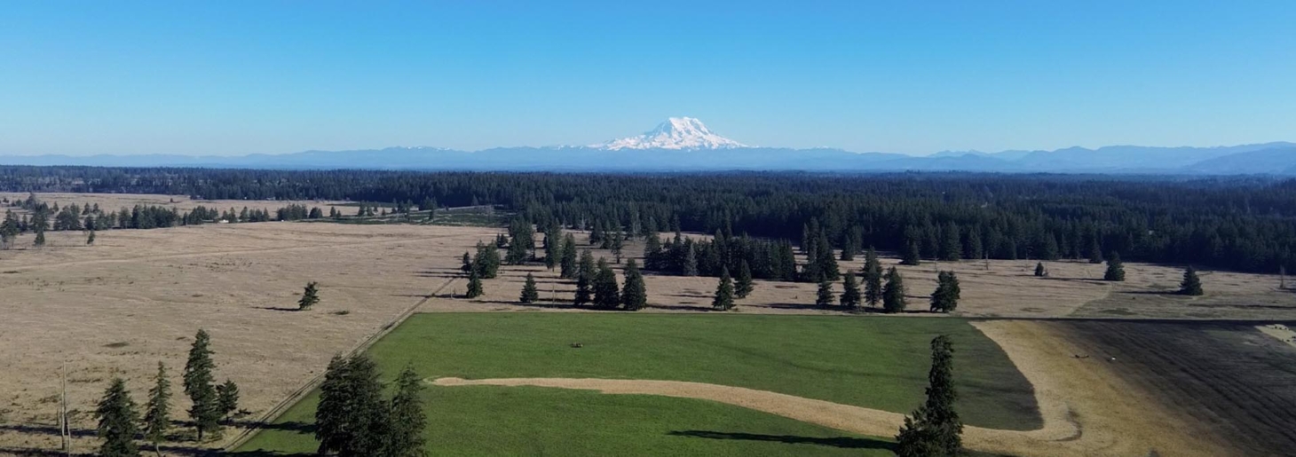
550.59 acres of High Fenced Phenomenal Hunting and Recreational Paradise in Marshall
550.59± Acres · Marshall County, Tennessee
🟡 Conditional Candidate
550.59± Acres in Marshall County, Tennessee has strong source-listed resilience signals, but the draft should stay conditional until water, access, utilities, zoning, and cost assumptions are verified.
Core Facts
- Price: $4,900,000
- Land: 550.59± Acres
- Broker/source: Josh Smith
- Source: Mossy Oak Properties
Resilience Read
- Water: 59± surveyed acres of managed wildlife habitat 24,650 linear feet of 8’ steel high fencing with predator control skirt 8 high-fence gates for easy, secure access 100-foot cleared buffer along fencing for simplified maintenance Enrolled in…
- Infrastructure: Species include White Oak, Sawtooth Oak, Red Oak, and Walnut Dense hardwood stands provide both wildlife cover and timber income potential Natural grapevines and fruit sources attract turkey and other wildlife Improvements & Infrastructure…
- Access: Legal access and road condition must be confirmed through survey, deed, and on-site review.
- Use potential: Encompassing 550.59 surveyed acres in scenic Marshall County, this rare offering combines exceptional wildlife management, income-producing timber, and comfortable accommodations—all within easy reach of Nashville and Huntsville. Property…
Property Media
Watch on Youtube Video sourced from original listing. If inline playback is unavailable, open the fallback link.


Images are sourced from the original listing for draft review; rights and final hosting should be confirmed before permanent publication.
Executive Summary
550.59 acres of High Fenced Phenomenal Hunting and Recreational Paradise in Marshall is a high-acreage Mossy Oak listing at $4,900,000, presented as 550.59± Acres in Marshall County, Tennessee. The extracted facts point to a substantial ranch/estate asset rather than a simple vacant-land parcel.
For Resilience Atlas purposes, the property is interesting because the source copy identifies several practical resilience signals: 59± surveyed acres of managed wildlife habitat 24,650 linear feet of 8’ steel high fencing with predator control skirt 8 high-fence gates for easy, secure access 100-foot cleared buffer along fencing for simplified maintenance Enrolled in…; Encompassing 550.59 surveyed acres in scenic Marshall County, this rare offering combines exceptional wildlife management, income-producing timber, and comfortable accommodations—all within easy reach of Nashville and Huntsville. Property….
This draft treats every listing claim as source-listed rather than independently verified. The property may merit deeper due diligence, but the next review should confirm county records, legal access, utility status, water reliability, zoning, restrictions, insurance exposure, and true development costs before any buyer-facing conclusion is hardened.
Initial Verdict: Conditional Candidate — worth deeper review if the source-listed land, water, access, infrastructure, and legal/buildability claims hold up under county and on-site due diligence.
Key Strengths
- Water or pond/creek potential appears in the source listing: 59± surveyed acres of managed wildlife habitat 24,650 linear feet of 8’ steel high fencing with predator control skirt 8 high-fence gates for easy, secure access 100-foot cleared buffer along fencing for simplified maintenance Enrolled in…
- Power or utility language appears in the source listing: Species include White Oak, Sawtooth Oak, Red Oak, and Walnut Dense hardwood stands provide both wildlife cover and timber income potential Natural grapevines and fruit sources attract turkey and other wildlife Improvements & Infrastructure…
- Land, timber, pasture, field, or terrain detail appears in the source listing: Encompassing 550.59 surveyed acres in scenic Marshall County, this rare offering combines exceptional wildlife management, income-producing timber, and comfortable accommodations—all within easy reach of Nashville and Huntsville. Property…
- Meaningful land base listed at 550.59± Acres, subject to usable-acreage and boundary verification.
Key Concerns
- All source claims remain unverified until county, utility, title, GIS, and on-site checks are completed.
- Zoning, deed restrictions, easements, floodplain/wetlands, and insurance constraints must be confirmed before any resilient-living plan is assumed.
- Domestic water, septic/perc, power, internet/cell service, and road maintenance costs could materially affect the property’s practicality.
- The deterministic extraction does not replace soil, survey, drainage, and build-site due diligence.
- Communications/connectivity remain unknown until site-level testing is complete.
Location Analysis
Regional Context
The source places the property in Marshall County, Tennessee. The report should treat regional context as promising but incomplete until drive times, emergency services, supply points, and county-level constraints are checked in km / miles.
The listing narrative provides the first pass, but a full intelligence report still needs map/GIS review to distinguish marketing proximity from practical year-round livability.
Access and Roads
Road frontage, driveway condition, private-road obligations, and emergency vehicle access were not fully resolved from the listing text.
Confirm legal access, recorded easements, road maintenance responsibility, gate/key arrangements, and wet-weather access before relying on the property for resilient use.
Distance to Services
Service distances were not verified in this deterministic run. Before buyer action, confirm grocery, hospital or urgent care, hardware, feed/farm supply, fuel, and emergency response distances in km / miles.
Land and Terrain
Acreage Usefulness
Encompassing 550.59 surveyed acres in scenic Marshall County, this rare offering combines exceptional wildlife management, income-producing timber, and comfortable accommodations—all within easy reach of Nashville and Huntsville. Property…
Soil and Growing Potential
Food-production potential should be treated as conditional until soils, drainage, pasture quality, fencing, irrigation options, and local growing constraints are verified.
Water Features
59± surveyed acres of managed wildlife habitat 24,650 linear feet of 8’ steel high fencing with predator control skirt 8 high-fence gates for easy, secure access 100-foot cleared buffer along fencing for simplified maintenance Enrolled in…
Utilities and Infrastructure
Power
Species include White Oak, Sawtooth Oak, Red Oak, and Walnut Dense hardwood stands provide both wildlife cover and timber income potential Natural grapevines and fruit sources attract turkey and other wildlife Improvements & Infrastructure…
Water
59± surveyed acres of managed wildlife habitat 24,650 linear feet of 8’ steel high fencing with predator control skirt 8 high-fence gates for easy, secure access 100-foot cleared buffer along fencing for simplified maintenance Enrolled in…
Septic and Waste
Septic or perc status was not clearly verified. Confirm existing permits, repair areas, soil suitability, and county rules before planning any dwelling.
Internet and Communications
Internet and cell coverage remain due-diligence items. Verify cellular service on site, FCC Broadband Map claims, Starlink visibility, and emergency communications options.
Off-Grid and Resilience Potential
Solar Suitability
Solar potential should be reviewed against tree cover, open ground, roof orientation if structures exist, battery location, and local permitting rules.
Heating and Cooling
Heating/cooling resilience depends on existing structures, climate exposure, insulation, wood or propane options, and backup-power planning. These details need on-site confirmation.
Food Production Potential
Encompassing 550.59 surveyed acres in scenic Marshall County, this rare offering combines exceptional wildlife management, income-producing timber, and comfortable accommodations—all within easy reach of Nashville and Huntsville. Property…
Security and Privacy
Privacy should be checked through parcel boundaries, road visibility, neighboring uses, terrain screening, and any shared-access arrangements. Avoid assuming seclusion from acreage alone.
Legal, Zoning, and Buildability
Zoning
Zoning, residential use, agricultural use, camping/RV rules, mobile/tiny-home rules, short-term rental limits, and multi-dwelling permissions are unknown until county review.
Permits and Restrictions
Confirm survey, easements, deed restrictions, HOA/covenants if any, wetlands/floodplain, timber/mineral rights, road agreements, and permit pathways before acquisition.
Risk Assessment
Environmental Risks
Environmental risk review should include FEMA floodplain, wildfire exposure, severe weather, erosion, drought resilience, pond/creek behavior, drainage, and insurance constraints.
Financial / Practical Cost Risks
The largest practical risk is cost uncertainty: utilities, road work, structures, water/septic, taxes, insurance, and maintenance could materially change the usable value of the property.
Practical Risks
The property should remain conditional until legal/buildable access, daily-service distances, communications, emergency response, and long-term manageability are verified.
Estimated Development Path
Phase 1: Due Diligence
Order a survey/title review; verify legal access, zoning, water, septic/perc, power, internet/cell, FEMA/GIS constraints, insurance, taxes, easements, and restrictions.
Phase 2: Basic Use
If due diligence is favorable, prioritize access cleanup, water testing or well quotes, communications testing, power/solar planning, secure storage, and a modest base-camp or maintenance plan.
Phase 3: Resilient Buildout
Long-term buildout could include a resilient dwelling or lodge plan, solar plus battery backup, backup generator, water storage, gardens/orchard, livestock infrastructure, greenhouse, and emergency communications.
Property Scorecard
Water details are based on listing claims and require county/on-site verification.
Privacy is estimated from the listing narrative and visible land context.
Food-production potential depends on usable acreage, soil, water, and slope still needing verification.
Infrastructure readiness reflects listed utilities, access, and structures where available.
Off-grid viability depends on solar exposure, water, legal use, and backup-system feasibility.
Connectivity must be verified with FCC, carrier maps, and an on-site signal test.
Terrain provides practical privacy and access-control context without fear-based framing.
Climate resilience requires local hazard review for flood, fire, heat/cold, and storm exposure.
Self-sufficiency depends on land usability, water, infrastructure, and legal constraints.
Access, zoning, septic, survey, and permits need buyer due diligence before commitment.
Final Recommendation
🟡 Conditional Candidate — the listing has enough land and source-listed resilience signals to justify deeper investigation, but it should not be treated as a finished recommendation until the major unknowns are verified.
The next decision point is not whether the marketing copy is attractive; it is whether water, access, utilities, zoning, insurance, maintenance burden, and true development costs support practical long-term use.
Rating context: Candidate levels reflect how well the property fits Resilience Atlas criteria after weighing infrastructure, water, access, buildability, communications, risk, and unresolved due diligence.
Questions to Ask Before Moving Forward
- Is legal access confirmed by deed, survey, and title work?
- What zoning, covenants, easements, or road-maintenance agreements apply?
- What domestic water source exists, and how reliable is it through dry periods?
- Is septic already permitted, or will a perc/site evaluation be required?
- What is the confirmed power, internet, and cellular-service situation on site?
- Are any parts of the property in floodplain, wetlands, steep-slope, or other restricted areas?
- What are annual taxes, insurance constraints, and maintenance costs?