Property Snapshot
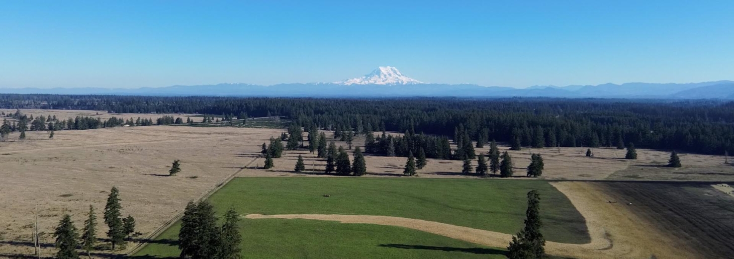
Vacation Home with Trees & Privacy
5.38 Acres · Fort Garland, Costilla County, Colorado · sourced from LOTFLIP
🟡 Conditional Candidate
Distinct from the LANDFLIP pick while still in the same affordable Colorado mountain market. Trees and privacy are resilience positives. Slightly larger than the 5-acre LANDFLIP selection. Same shared-inventory caveat applies.
Core Facts
- Price: $15,500
- Land: 5.38 Acres with land-use details drawn from the listing where available.
- Property type: Rural land / retreat / homestead candidate; exact legal category should be verified locally.
- Best fit: Resilience Atlas readers looking for privacy, practical land use, and a realistic due-diligence path.
Resilience Read
- Water: the Conejos River, Rio de los Pinos, and Red River (Nm) all offer classic mountain fishing, and blue-ribbon trout waters on the upper Rio Grande near Del Norte are just an hour away.
- Infrastructure: Existing improvements are referenced in the listing.
- Access: Legal access, driveway condition, and emergency access should be confirmed before any offer.
- Use potential: trees and privacy; mountain location; affordable
Source: LOTFLIP listing
Reviewed: 2026-05-17 · Coordinates: not confirmed in this batch
Property Media
Listing media is shown for review and attribution; rights and reuse should be confirmed before any permanent hosted use.


Source listing: LOTFLIP
Executive Summary
Vacation Home with Trees & Privacy is a 5.38 Acres property in Fort Garland, Costilla County, Colorado selected for this Resilience Atlas 10-source QA batch. The listing presents it as a candidate with reader-facing appeal because of trees and privacy, mountain location, affordable, owner financing.
This report treats the listing as an intelligence starting point rather than verified due diligence. The strongest case for further review is its combination of land, setting, and potential practical use. The largest caution is that public listing claims still need confirmation through county records, survey, utility providers, flood mapping, soils, and on-site inspection.
Initial Verdict:
🟡 Conditional Candidate — worth deeper review if the unresolved water, access, zoning, and infrastructure questions check out.
Key Strengths
- trees and privacy
- mountain location
- affordable
- owner financing
- Extracted listing detail was sufficient to support a structured preliminary intelligence report.
- Potential to serve as a useful reader case study for resilient land selection and due diligence.
Key Concerns
- small lot limits self-sufficiency
- same shared FLIP inventory
- high altitude growing constraints
- County GIS, FEMA flood maps, USDA soils, FCC broadband, Regrid parcel data, and CellMapper coverage were not fully verified in this publishing pass.
- All listing claims should be treated as unverified until confirmed by documents and inspection.
Location Analysis
Regional Context
The property is presented in or near Fort Garland, Costilla County, Colorado. Its suitability for resilient living depends on local climate, fire/flood exposure, service access, and the practical distance to supplies and emergency services. Specific drive distances should be confirmed with live maps before purchase; any published map estimate should include both km / miles.
Access and Roads
Road frontage, driveway quality, seasonal access, snow or mud limitations, and emergency vehicle turnaround should be verified on site. If the property uses private roads, confirm maintenance agreements and legal easements in writing.
Distance to Services
Grocery, hospital or urgent care, fuel, building supplies, feed stores, fire response, and law enforcement distances were not fully verified in this batch. Buyers should map each service and record distances in km / miles before relying on the property for long-term occupancy.
Land and Terrain
Acreage Usefulness
5.38 Acres provides the starting point for privacy, gardens, livestock, timber, and internal road planning. Actual usable acreage may be lower after accounting for slope, drainage, setbacks, wetlands, easements, and buildable-area limits.
Soil and Growing Potential
Garden, orchard, pasture, and livestock potential should be verified through USDA Web Soil Survey, local extension guidance, and on-site soil testing. Listing language is useful as a lead, but not enough for crop or livestock planning.
Water Features
the Conejos River, Rio de los Pinos, and Red River (Nm) all offer classic mountain fishing, and blue-ribbon trout waters on the upper Rio Grande near Del Norte are just an hour away.
Utilities and Infrastructure
Power
Grid power availability, line-extension cost, transformer distance, and backup-power options should be confirmed with the utility. Solar can be part of the resilience plan, but tree cover, winter production, local code, and battery siting must be evaluated.
Water
Verify whether the property has an existing well, shared/community water, permitted surface-water use, or realistic rain/haul/cistern options. Ask for well logs, flow rates, potability tests, and any water-right documents.
Septic and Waste
Confirm septic status, perc results, soil limitations, and county rules for composting toilets, RV use, tiny homes, and temporary occupancy. Septic uncertainty is often a major cost risk.
Internet and Communications
FCC broadband data, local ISP availability, cellular signal, and Starlink obstruction should be tested directly. Emergency communications planning should include radio line-of-sight, backup power, and weather alert coverage.
Off-Grid and Resilience Potential
Solar Suitability
The off-grid case depends on sun exposure, panel placement, snow/wind loading, and battery storage. A proper solar site assessment should be completed before relying on the property for independent power.
Heating and Cooling
Heating/cooling resilience depends on local climate, building envelope, fuel availability, wood access, propane logistics, and passive design. Confirm insurance constraints for wood stoves and remote structures.
Food Production Potential
Food production may include gardens, orchards, poultry, small livestock, greenhouse use, hunting, fishing, or forage depending on soils, water, fencing, and local rules. Do not assume livestock or intensive agriculture is allowed without zoning review.
Security and Privacy
Privacy should be evaluated practically: road visibility, neighbor proximity, gate placement, fencing, terrain, and alternate access. This is not a fear-based assessment; it is about livability, control, and quiet rural use.
Legal, Zoning, and Buildability
Zoning
Zoning info: Estate Residential
Permits and Restrictions
Ask for recorded covenants, HOA documents, easements, road agreements, mineral/timber rights, wetlands/floodplain overlays, and conservation restrictions. Do not rely on marketing copy for legal use rights.
Risk Assessment
Environmental Risks
Flood, wildfire, drought, extreme heat/cold, storms, erosion, and drainage should be checked through FEMA, state hazard tools, county GIS, and insurance conversations. Properties with attractive water features can also carry flood or access risk.
Financial / Practical Cost Risks
Development costs can exceed land price when wells, septic, roads, power, fencing, structures, and insurance are unresolved. Get written quotes for the first-phase improvements before assuming the property is usable.
Practical Risks
The main practical risks are legal access, water reliability, buildability, local code limits, maintenance burden, and service distance. A strong listing can still fail if those basics do not verify.
Estimated Development Path
Phase 1: Due Diligence
Confirm survey, title, legal access, zoning, floodplain/wetlands, water, septic/perc, utility costs, taxes, insurance, broadband/cell service, and any restrictions. Record key service distances in km / miles.
Phase 2: Basic Use
Possible early steps include access cleanup, a legal temporary base, storage, water testing or well quotes, a solar assessment, basic gate/signage, and communications testing.
Phase 3: Resilient Buildout
Long-term upgrades could include a cabin or home, solar plus batteries, backup generator, gardens/orchard, livestock infrastructure, greenhouse, rainwater catchment where legal, improved fencing, and emergency communications.
Property Scorecard
Weighted toward visible or claimed surface water, wells, or practical catchment options; all claims need local verification.
Based on acreage, rural setting, road exposure, and likely neighbor separation.
Reflects acreage, pasture/timber mix, soils implied by source details, and likely garden/livestock practicality.
Scores existing homes, utilities, roads, barns, fencing, or other usable improvements.
Reflects solar exposure, backup potential, regulatory flexibility, and low-dependency setup options.
Internet and cell service remain due-diligence items unless the listing states a clear service.
A practical privacy/access-readiness measure, not a tactical or fear-based rating.
Considers heat/cold, drought, flood exposure, wildfire context, and seasonal practicality.
Combined view of water, land use, infrastructure, and long-term homestead capacity.
How well the property can carry a premium Resilience Atlas feature.
Reader-facing appeal: water, cabin/ranch identity, scenery, and self-reliance narrative.
Legal access, zoning clues, road usability, and likely permitting complexity.
Candidate levels reflect fit with Resilience Atlas criteria after weighing water, infrastructure, access, buildability, communications, risk, and unresolved due diligence.
Final Recommendation
🟡 Conditional Candidate
Vacation Home with Trees & Privacy should move forward only if its major due-diligence questions verify cleanly. The property has enough resilience-media value to justify deeper research, but the listing alone is not proof of water security, buildability, communications, or legal livability.
Rating context: Candidate levels reflect how well the property fits Resilience Atlas criteria after weighing infrastructure, water, access, buildability, communications, risk, and unresolved due diligence.
Questions to Ask Before Moving Forward
- Is legal access confirmed by deed, survey, or recorded easement?
- What is the current zoning, and what uses are allowed by right?
- Is there a recent survey?
- Has a perc test been completed?
- Is there an existing well or reliable domestic water option?
- What would power installation or off-grid solar cost?
- Is off-grid living legally allowed?
- Are RVs, cabins, tiny homes, mobile homes, or multiple dwellings restricted?
- Is any part of the property in a floodplain or wetland area?
- What are the annual taxes and insurance constraints?
- Are there easements, covenants, mineral rights, timber rights, or road agreements?