Harrison County Missouri 76-Acre Grass Farm — Resilience Atlas Property Intelligence Report
A full Resilience Atlas Property Intelligence Report based on the public Whitetail Properties listing, rendered media review, and preliminary desktop due-diligence starting points. Listing claims are not independently verified unless specifically stated.
Property Snapshot
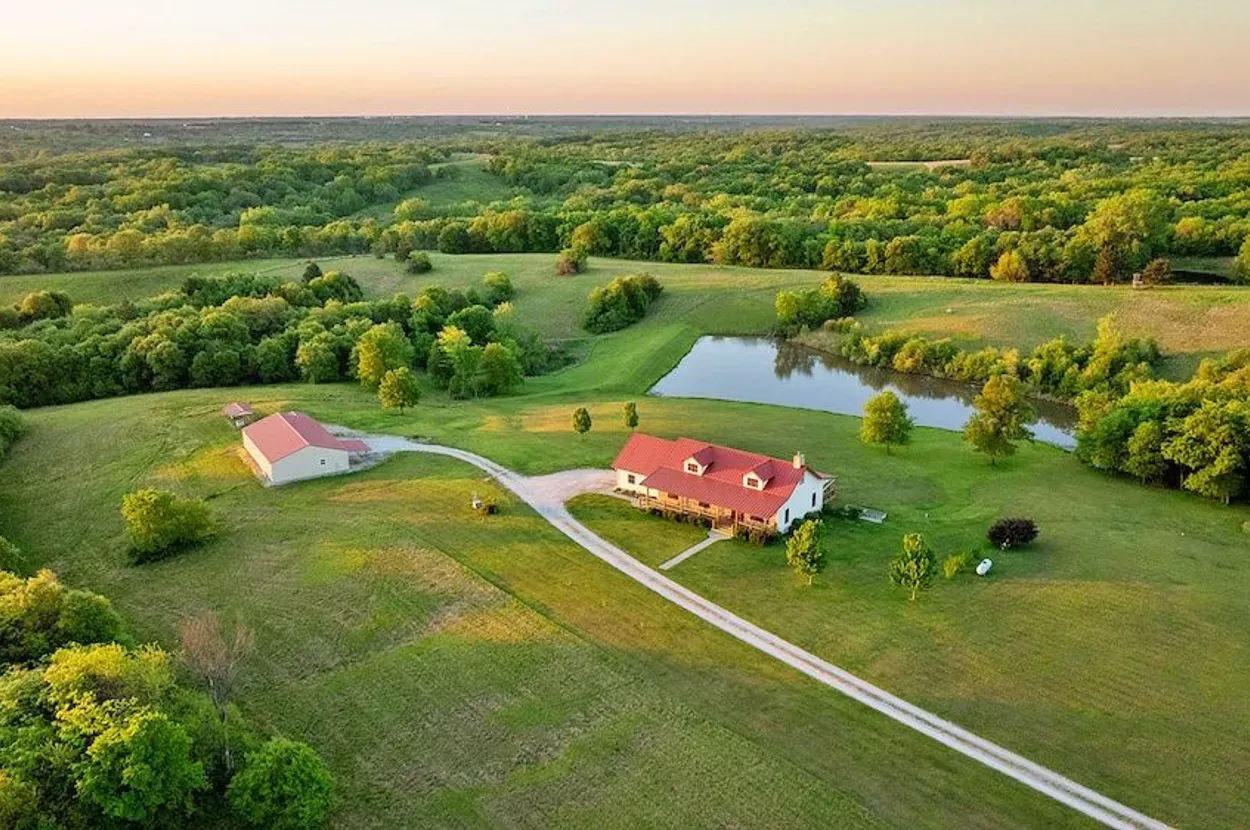
Harrison County grass-and-timber farm with home and ponds
76.24± acres · Harrison County, Missouri · near Bethany
🟢 Strong Candidate · 94/120
This is a strong premium Resilience Atlas candidate because it combines a livable 2014 home, onsite utilities, useful outbuildings, ponds, pasture/timber balance, and adjacency to Grand Trace Conservation Area.
Core Facts
- Price: $1,200,000, per listing.
- Land: 76.24± acres with grassland, pasture, timber, wooded draws, and ponds, per listing.
- Address: 25692 W 168th Ave, Bethany, MO 64424, Harrison County.
- Coordinates: 40.3427, -94.1038, from the listing.
- Property type: Farm, recreational land, and residential land.
- Best fit: Turnkey rural homestead, livestock/hay base, hunting/recreation property, and staged resilient-living platform.
Resilience Read
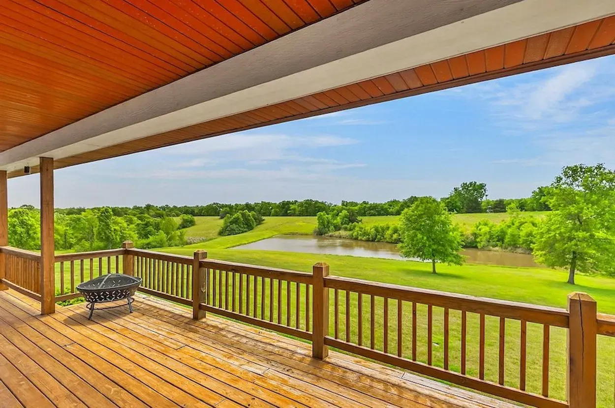
- Water: Listing claims a 1+ acre pond plus a smaller pond and onsite water. Source, quality, and long-term reliability need verification.
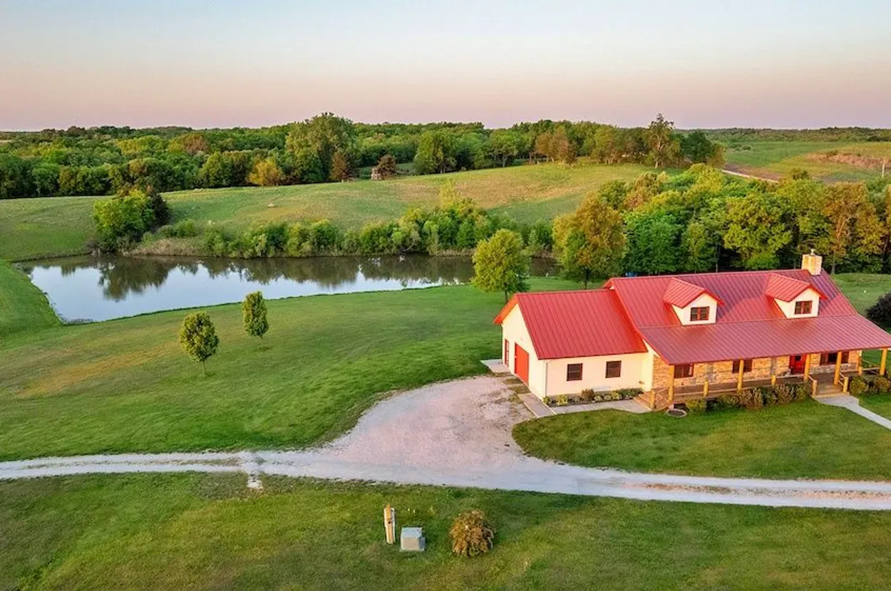
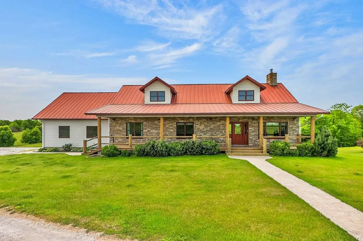
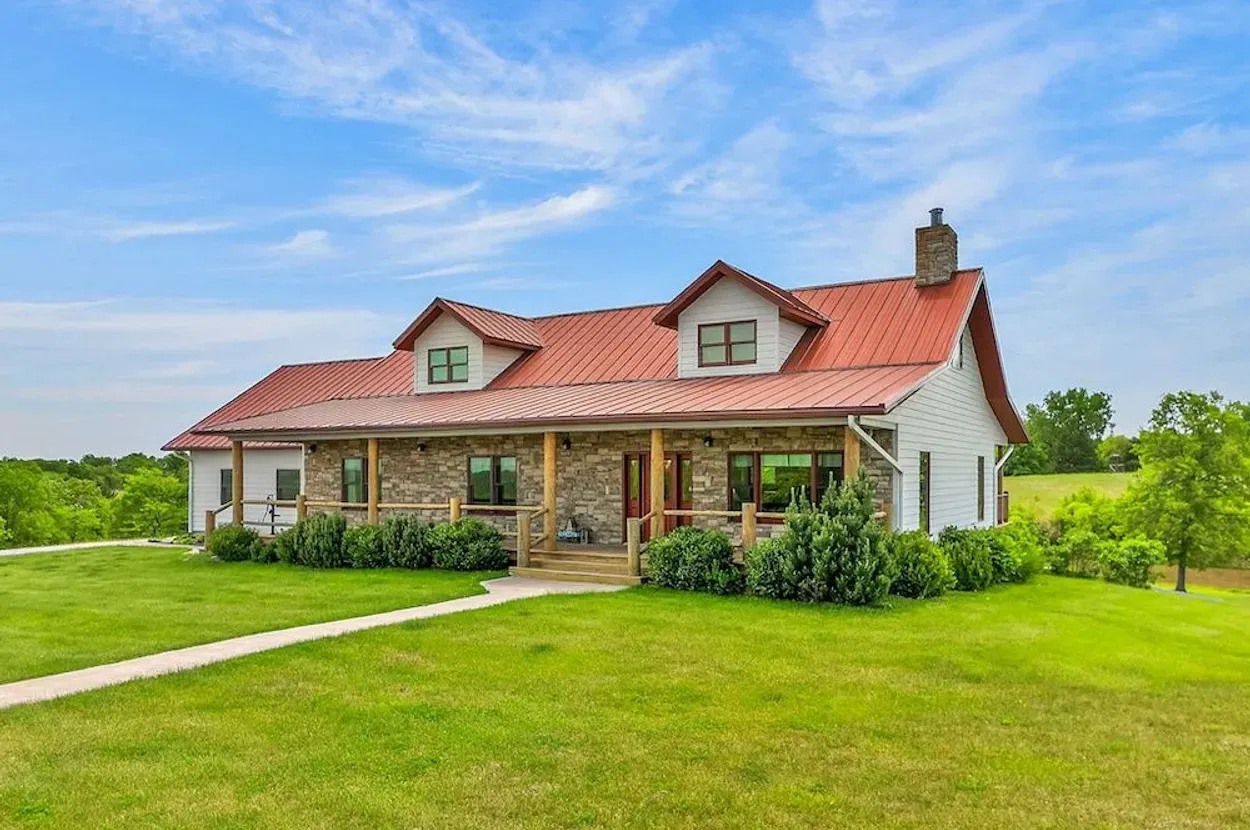
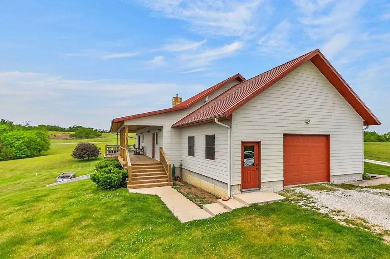
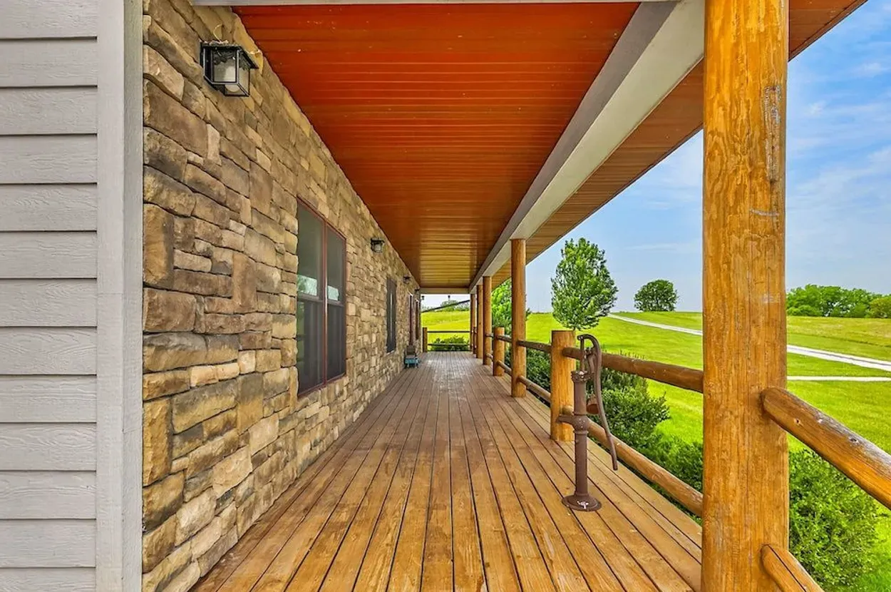
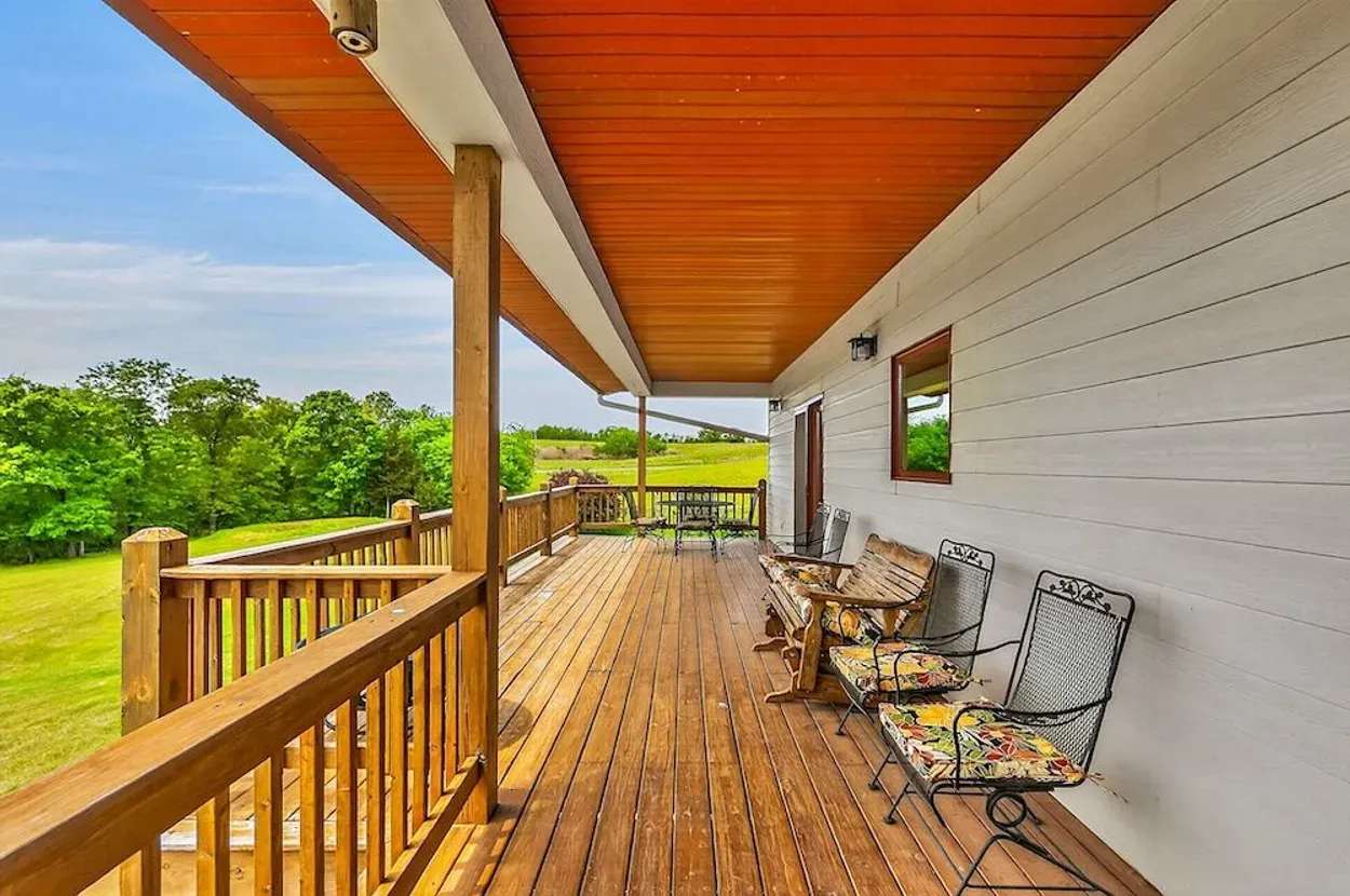
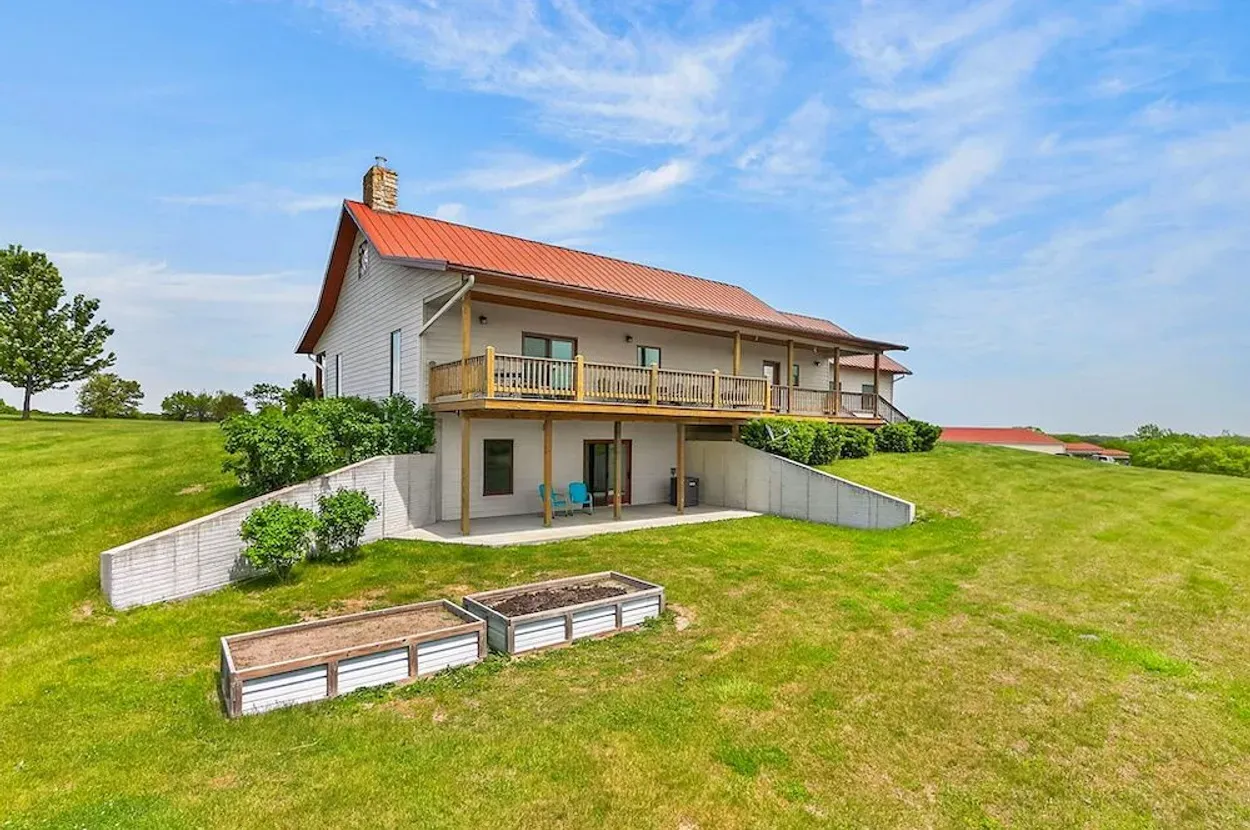
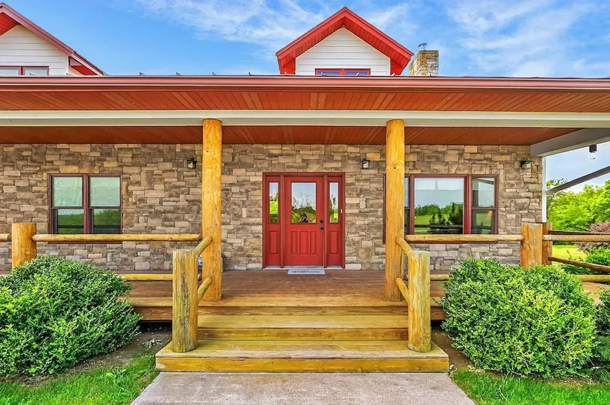
- Infrastructure: Listing claims a 3 bed / 2 bath, 3,520± sq ft home built in 2014, attached garage, 36x64 outbuilding with finished 16x36 space, kitchenette and bathroom, plus a 16x40 hay shed.
- Access: County road frontage and gravel road surface are listed. Legal access, road maintenance, and exact frontage should still be confirmed.
- Use potential: Strong for immediate rural living, livestock, gardens, hay, equipment storage, hunting, and phased backup-power/self-sufficiency upgrades.
Source: Whitetail Properties listing
Reviewed: May 19, 2026 · Coordinates: 40.3427, -94.1038
Property Media
Curated from the Whitetail Properties listing media after visual screening for property-focused, landscape-oriented images. Listing media and all claims remain third-party source material until independently verified.
Media source: Whitetail Properties listing.
Executive Summary
This 76.24± acre Harrison County property near Bethany, Missouri is one of the cleaner full-report candidates in the Whitetail test batch. The listing presents it as a working rural home-on-acreage with pasture, timber, grass ridges, wooded draws, ponds, a 2014 custom home, shop space, hay storage, onsite electric, onsite water, and onsite internet.
For Resilience Atlas, the strength is not a single dramatic feature. It is the combination: a livable home already in place, practical outbuildings, land that appears useful for grazing or hay, pond water, and immediate adjacency to the 1,500+ acre Grand Trace Conservation Area. That gives the property a broad rural-livability story without having to force a “remote retreat” narrative.
The main concerns are the usual but important ones: the water source is not clearly described, septic/waste details are not provided in the extracted listing text, zoning and restrictions are unknown, and the onsite internet claim needs provider/speed verification. The price is also high enough that insurance, taxes, inspection findings, and infrastructure condition matter.
Initial Verdict:
Strong Candidate. This property deserves deeper due diligence if the goal is a turnkey rural base with room for food production, backup systems, equipment storage, and long-term self-sufficiency improvements.
Key Strengths
- Existing 3 bed / 2 bath, 3,520± sq ft home built in 2014, per listing.
- Onsite electric, water, and internet claimed in the listing.
- 1+ acre pond plus a smaller pond claimed in the listing.
- Useful outbuilding mix: 36x64 shop/outbuilding with finished section, kitchenette, and bathroom, plus hay shed.
- Pasture, grass, timber, and wooded draws support multiple rural uses.
- Adjoins Grand Trace Conservation Area, adding a strong public-land and recreation story.
- County road frontage and gravel road surface are practical access signals.
- Deep media set from Whitetail supports a strong visual report.
Key Concerns
- Listing claims have not been independently verified.
- Water source details, water quality, pond permanence, and domestic water reliability remain unknown.
- Septic/waste system details were not clear in the extracted listing text.
- Zoning, deed restrictions, easements, survey, and outbuilding compliance need county/title verification.
- Internet type, speed, provider, and cellular coverage need field testing.
- Floodplain/wetland status and soil suitability for garden/livestock use need independent checks.
- At the listed price, inspections, insurance, taxes, utility condition, and maintenance costs matter.
Location Analysis
Regional Context
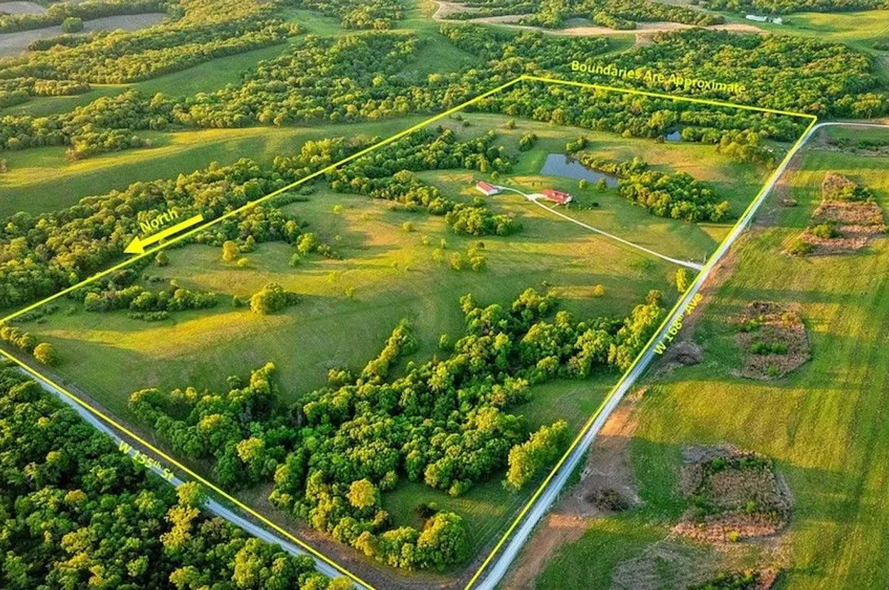
The property is near Bethany in Harrison County, northwest Missouri. The listing places it at 25692 W 168th Ave, Bethany, MO 64424, with coordinates 40.3427, -94.1038. This is a rural agricultural/recreational setting rather than a suburban acreage.
The listing says the property adjoins Grand Trace Conservation Area and is about 11.3 km / 7 miles from Harrison County Lake and about 16.1 km / 10 miles from Bethany. Those distances make it rural, but not impractically isolated for a property with an existing home.
Northwest Missouri can support pasture, hay, gardens, orchards, poultry, livestock, and woodlot-style self-sufficiency planning, but buyers should evaluate severe storm exposure, winter access, summer heat, drought cycles, and insurance availability.
Access and Roads
The listing identifies county road frontage and a gravel road surface. That is favorable compared with landlocked or private-road-only parcels, but exact frontage, legal access, driveway condition, road maintenance responsibility, and emergency-vehicle access still require confirmation.
Distance to Services
Listing distances place the property about 16.1 km / 10 miles from Bethany. Bethany is the logical first stop for groceries, fuel, basic hardware, farm supplies, emergency services, and the Harrison County Community Hospital area. Road time should be tested directly from the driveway, especially in winter or severe weather.
Harrison County Lake is listed at about 11.3 km / 7 miles away. Grand Trace Conservation Area adjoins the property according to the listing, which matters for recreation and landscape context but should not be treated as private buffer acreage.
Land and Terrain
Acreage Usefulness
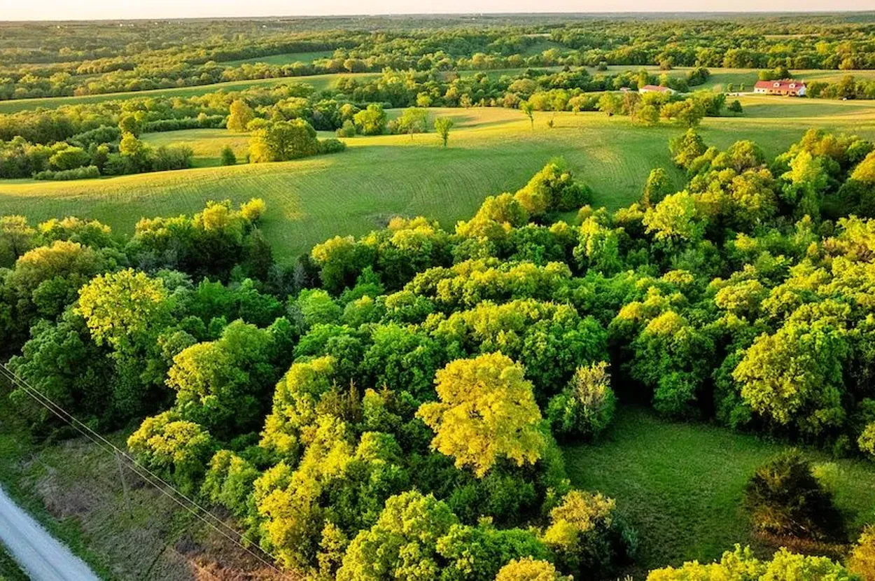
At 76.24± acres, the property is large enough to support a mixed rural program: a home base, shop/equipment area, hay or grazing ground, garden/orchard zones, pond management, wildlife habitat, and privacy buffers. The listing describes open grass ridges, deep wooded draws, grassland, timber, pasture, and pond features.
The mix is more useful for a Resilience Atlas reader than a single-purpose wooded tract. Open ground helps food production and solar planning; timber and draws support wildlife, shade, privacy, and possible woodlot use.
Soil and Growing Potential
The listing’s pasture/grass/hay signals are promising, but soil quality is not verified. A buyer should use USDA Web Soil Survey, county soil maps, and on-site tests before assuming vegetable production, orchard suitability, livestock stocking rates, or septic viability.
Water Features
The listing claims a large, deep, 1+ acre pond plus a smaller pond. That is a meaningful resilience signal for livestock, gardens, wildlife, fire-suppression planning, and general landscape value. Domestic water, water rights, pond permanence, water quality, and whether ponds are spring-fed, runoff-fed, or otherwise managed are not verified.
Utilities and Infrastructure
Power
The listing claims onsite electric and references a separate electric meter near the hay shed. That is a major readiness advantage. Buyers should confirm account status, service capacity, panel condition, utility provider, outage history, and upgrade costs for backup systems, shop loads, or future outbuilding use.
Water
The listing claims onsite water and extra water service near the hay shed, but the extracted listing does not clearly state whether this is well water, rural water, public water, or another system. This is one of the most important due-diligence items.
Septic and Waste
The home and finished outbuilding/bathroom imply waste-system infrastructure, but septic details were not provided in the extracted listing text. Confirm septic permit, tank/field location, inspection history, capacity, repair/replacement risk, and whether the outbuilding bathroom is permitted and correctly connected.
Internet and Communications
The listing says internet is onsite. That is encouraging but insufficient for a resilience report conclusion. Confirm provider, speed, latency, contract terms, cellular signal from multiple carriers, Starlink line-of-sight, and backup communications options.
Off-Grid and Resilience Potential
Solar Suitability
The property appears promising for solar because it includes open ground and existing buildings, but actual solar suitability depends on tree shade, roof orientation, ground-mount siting, interconnection rules, battery location, and local permitting. A buyer should evaluate both grid-tied backup and standalone critical-load systems.
Heating and Cooling
The listing notes a stone fireplace as a living-area feature. Buyers should confirm whether it is functional, decorative, wood-burning, gas, or otherwise configured. Backup heat planning should include wood, propane, generator-supported heat pumps, passive-solar improvements, and freeze protection.
Food Production Potential
The pasture, grassland, hay shed, ponds, and outbuildings create a strong base for gardens, poultry, small livestock, hay, orchard plantings, greenhouse space, and equipment storage. The limiting factors will be soils, fencing, water access points, slope, drainage, and local rules.
Security and Privacy
The acreage, wooded draws, ridges, and rural setting provide natural privacy and visual separation. The county-road access is practical but also means this is not an invisible or deep-remote holding. Treat it as a resilient rural homestead candidate, not a hardened compound.
Legal, Zoning, and Buildability
Zoning
Zoning was not verified in this pass. Because the property already includes a home and outbuildings, existing residential/agricultural use appears plausible from the listing, but buyers should confirm county zoning, permitted agricultural uses, additional dwelling rules, RV/tiny-home/camping rules, short-term rental rules, and any restrictions affecting livestock or business use.
Permits and Restrictions
Confirm the survey, legal description, easements, road agreements, utility easements, septic permits, building permits, outbuilding compliance, pond/dam responsibilities, timber/mineral rights, floodplain/wetland status, and any conservation or deed restrictions. Do not rely on listing maps as boundary proof.
Risk Assessment
Environmental Risks
Key environmental checks include FEMA flood mapping, pond drainage and dam condition, wetland indicators, soil erosion, severe-storm exposure, drought resilience, wildfire/grassfire risk, winter weather, and extreme heat. The desktop pass found no verified flood or wetland conclusion; this remains due diligence.
Financial / Practical Cost Risks
The property is much more infrastructure-ready than raw land, but that shifts the risk toward inspection findings and operating costs. Evaluate roof, siding, HVAC, plumbing, electrical, septic, water system, outbuilding condition, road/driveway maintenance, pond maintenance, insurance, taxes, and utility bills.
Practical Risks
The biggest practical risks are over-trusting the listing’s utility claims, underestimating maintenance on a large home and multiple outbuildings, assuming internet quality from the word “onsite,” and assuming the adjoining conservation area functions like private buffer land.
Estimated Development Path
Phase 1: Due Diligence
Confirm survey, title, legal access, zoning, restrictions, floodplain/wetlands, septic system, domestic water source, pond condition, utility capacity, internet provider/speed, cell coverage, insurance, taxes, inspection results, outbuilding permits, and soil suitability.
Phase 2: Basic Use
Assuming inspections pass, early improvements could include water testing, pond assessment, driveway and gate review, fencing repair, garden/orchard soil tests, basic livestock planning, generator interlock or transfer switch, Starlink/cell backup testing, and security lighting/cameras.
Phase 3: Resilient Buildout
Longer-term upgrades could include solar plus battery for critical loads, backup generator fuel plan, rainwater catchment for non-potable uses where legal, greenhouse/high tunnel, orchard, rotational grazing, chicken setup, expanded pantry/cold storage, radio communications, and a written emergency-access plan.
Property Scorecard
Two ponds are listed, including a 1+ acre pond, with onsite water claimed. Water source, water quality, pond permanence, and legal/domestic water details still need verification.
The acreage has wooded draws, open ridges, and adjacency to Grand Trace Conservation Area. It is not a deep-remote property, but the land mix and rural setting support meaningful privacy.
Pasture, grassland, hay-shed infrastructure, and water/electric service create practical livestock, hay, garden, and small-farm potential, subject to soils and fencing verification.
A 2014 home, garage, shop, hay shed, concrete-floor outbuilding, finished utility space, onsite electric, onsite water, and onsite internet make this unusually ready for immediate rural use.
Existing infrastructure lowers the starting burden, and the open land should help solar siting. A true off-grid/backup plan would still require system design, battery/generator sizing, and legal review.
The listing says internet is onsite. Actual provider, speed, redundancy options, cellular coverage, and Starlink suitability remain due-diligence items.
Open ridges, wooded draws, county-road access, and a home placed above the landscape offer good visibility and natural separation without implying a hardened retreat.
Northwest Missouri brings four-season livability, agricultural usefulness, and water-storage opportunity, but also severe-storm, winter, drought, heat, and insurance questions.
The home, outbuildings, ponds, grass/timber mix, hay shed, and utility services create a strong platform for a staged resilient-living buildout.
This is a visually rich and narratively complete Whitetail candidate: turnkey home, productive acreage, ponds, conservation-area adjacency, and 116 listing photos.
The combination of porch views, pond, farm structures, wildlife habitat, and a real house on usable acreage gives it strong reader appeal without needing hype.
County-road frontage, gravel road surface, existing structures, and active utilities are strong practical signals. Survey, easements, zoning, septic, and compliance still need confirmation.
94/120 · 🟢 Strong Candidate. The score is high because the property is already livable and infrastructure-rich while still offering water, land-use flexibility, and strong narrative depth. It is not a final investment or purchase recommendation.
Final Recommendation
🟢 Strong Candidate
This property should move to deeper due diligence if the goal is a turnkey rural base with practical self-sufficiency potential. The strongest case is the combination of house, utilities, ponds, outbuildings, pasture/timber mix, and conservation-area adjacency.
The property is not risk-free. The buyer needs to verify water, septic, zoning, restrictions, internet, flood/wetland status, and building/outbuilding condition before treating it as a true resilience-ready homestead.
Rating context: Candidate levels reflect how well the property fits Resilience Atlas criteria after weighing infrastructure, water, access, buildability, communications, risk, and unresolved due diligence.
Questions to Ask Before Moving Forward
- Is legal access confirmed by survey, deed, and title work?
- What is the exact zoning, and what rural/agricultural uses are allowed?
- Are there covenants, easements, road agreements, utility easements, or conservation restrictions?
- What is the domestic water source: well, rural/public water, or another system?
- Has the water been tested recently, and what are the results?
- What is the septic system age, size, layout, permit history, and inspection status?
- Are both the home and outbuilding bathroom properly permitted and connected?
- What are the real internet provider, speed, latency, and outage history?
- What cellular carriers work on the property and at the home site?
- Is any part of the property in a FEMA floodplain, wetland, or drainage restriction area?
- What are the pond depth, source, dam/spillway condition, and maintenance obligations?
- What does insurance cost for the home, outbuildings, ponds, and rural acreage?
- Are mineral, timber, hunting, and water rights included without reservation?
- What inspection issues exist with the roof, HVAC, plumbing, electrical, foundation, fireplace, and outbuildings?
Source / Verification Starting Points
- Primary listing: Whitetail Properties listing.
- Listing area links: Grand Trace Conservation Area and Harrison County Lake.
- County/title checks: Harrison County assessor/GIS, recorder, planning/zoning office, and title company review.
- Flood/wetland checks: FEMA Flood Map Service Center and National Wetlands Inventory using the property coordinates and parcel boundary.
- Soil/topography checks: USDA Web Soil Survey and USGS elevation/topographic data. A USGS point-elevation query at the listing coordinates returned approximately 309 m / 1,015 ft above sea level, but parcel-wide slope and soil conditions were not verified.
- Communications checks: FCC Broadband Map, provider address lookup, carrier field tests, and Starlink line-of-sight check.
- On-site checks: Water test, septic inspection, pond/dam inspection, driveway/road review, utility-capacity review, and full home/outbuilding inspection.
Due-diligence warning: This report is a resilience-media intelligence assessment, not legal, engineering, environmental, financial, or brokerage advice. All listing claims, measurements, utility claims, boundaries, access, and suitability questions should be independently verified before purchase or publication-level reliance.