A Resilience Atlas Property Intelligence Report based on the Mossy Oak Properties source listing, browser-grade extraction, and supporting evidence compiled May 22, 2026. Listing claims are treated as unverified unless specifically noted.
Property Snapshot
Lost Brake: The Island
1,150± acres · Pemiscot County, Missouri · Mississippi River island near Hayti / Lee Towhead
🟡 Conditional Candidate · 60/100
A rare Mississippi River island sanctuary with extraordinary privacy, habitat, camp infrastructure, and resilience potential — but access, river/flood risk, utilities, communications, legal boundaries, and camp compliance need unusually careful due diligence.
Core Facts
- Price: $5,900,000; source-listed at about $5,130 per acre.
- Land: 1,150± acres of source-described island, riverfront, flooded cypress/tupelo brake, mixed timber, moist-soil units, food plots, and managed wildlife habitat.
- Property type: Hunting land, recreational land, riverfront, farm/business opportunity, and private camp-style retreat.
- Best fit: High-capacity hunting/fishing retreat, private wildlife sanctuary, Mississippi Flyway camp, or conservation-minded recreational holding.
Resilience Read
- Water: River access, wetlands/brakes, moist-soil units, and water-control structures are major strengths; potable water and legal water use are unknown.
- Infrastructure: The listing claims a furnished camphouse, permanent blinds, barge, water-control structures, and management equipment, but utility systems and condition need verification.
- Access: The listing describes access by grass strip airplane, chopper, or boat, with a barge for vehicle/equipment transport; no conventional road access is established.
- Use potential: Strong for controlled recreation, hunting, fishing, habitat management, and a private seasonal camp; uncertain for ordinary residential living or low-complexity homesteading.
Source: Mossy Oak Properties listing
Reviewed: May 22, 2026 · Coordinates: source-listed 36.264512, -89.547299
Property Media
Selected property-focused listing media, prioritizing aerials, river context, habitat, food plots, camp/access context, and non-people-primary images.


Image source: Mossy Oak Properties / RealStack listing media. External listing images are used for draft review; reuse rights should be confirmed before long-term publication strategy.
Listing Video
Source listing video on YouTube · Additional Lost Brake series video source
Executive Summary
Lost Brake: The Island is a source-listed 1,150± acre Mississippi River island property in Pemiscot County, Missouri. The listing presents it as a managed, high-end hunting and recreational sanctuary in the Mississippi Flyway, with river isolation, flooded cypress and tupelo brakes, moist-soil units, food plots, mixed timber, water-control infrastructure, permanent blinds, and a furnished camphouse.
For Resilience Atlas, the property is compelling because it combines scale, privacy, water, habitat, media depth, and a distinctive island-camp story. It is not just raw acreage; the listing claims substantial operational infrastructure including a camphouse that sleeps 20+ guests, an 800 sq ft porch overlooking the Mississippi River, a barge for vehicle and equipment transport, management equipment, and established food plots.
The same features that make it special also make it complex. The evidence does not confirm conventional road access, domestic water, septic, grid power, solar, internet, cell coverage, legal access instruments, aircraft permissions, floodplain/wetlands constraints, river-boundary/accretion issues, or camp code/insurance status. This is a serious due-diligence property, not a casual rural-home purchase.
Initial Verdict:
Conditional candidate for a buyer seeking an exceptional private hunting, fishing, and river-island retreat, provided the legal access, flood/river, utility, communications, equipment, and camp-compliance questions can be resolved in writing.
Key Strengths
- Rare 1,150± acre Mississippi River island setting with natural privacy and a strong sense of separation.
- Source-listed water and habitat assets: river access, flooded cypress/tupelo brakes, moist-soil units, food plots, timber, and water-control infrastructure.
- Substantial claimed recreation infrastructure: furnished camphouse, 20+ guest capacity, 800 sq ft porch, permanent blinds, barge, and management equipment.
- Strong wildlife and seasonal-use story across mallards, whitetail deer, turkey, small game, fishing, and habitat management.
- Excellent media and narrative quality for a flagship Resilience Atlas property report.
Key Concerns
- No conventional road access is described; access is by grass strip airplane, chopper, or boat, with barge logistics central to the property.
- Domestic water, septic, grid/generator/solar power, internet, cell coverage, and emergency communications are not specified in the extracted listing evidence.
- Mississippi River floodplain, wetlands, erosion/accretion, river boundary, riparian rights, and insurance constraints could materially affect ownership and use.
- Camp permits, code compliance, flood elevation, structure condition, wastewater capacity, and occupancy for 20+ guests require direct verification.
- Included barge/equipment/furnishings, titles, liens, condition, and exclusions need to be documented in the purchase agreement.
Location Analysis
Regional Context
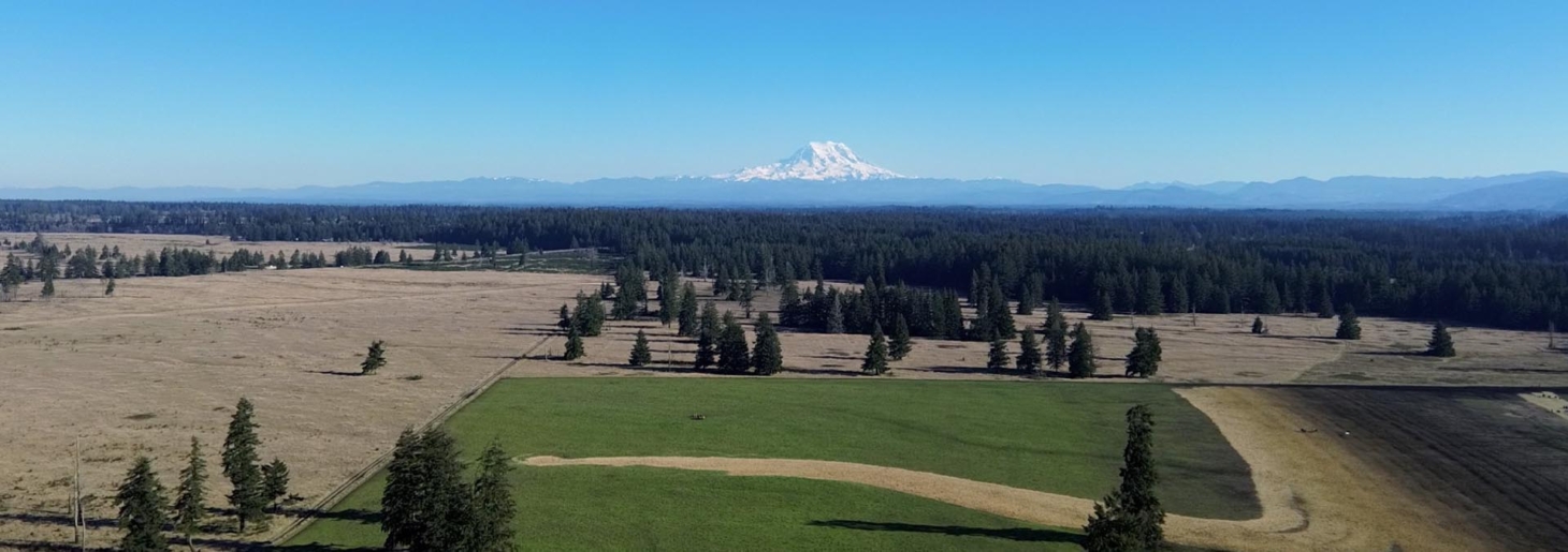
The listing places the property at Lee Towhead on the Mississippi River near Hayti in Pemiscot County, Missouri, with source-listed coordinates at 36.264512, -89.547299. Independent reverse geocoding of those coordinates returned Pemiscot County, Missouri, which is consistent with the listing’s regional placement.
This is a Southeast Missouri Delta / Mississippi Flyway setting rather than a typical county-road homestead. The regional strengths are waterfowl habitat, river access, agricultural lowlands nearby, small-town service access, and a strong hunting-camp culture. The practical challenge is that island access, river stage, weather, and emergency response matter more here than ordinary driveway distance.
Access and Roads
The source listing’s access language is direct: “Grass strip airplane, chopper or boat.” It also says an essential barge is included for vehicle and equipment transport. That makes legal access, boat landing rights, launch/landing locations, barge route, seasonal river-stage limits, aircraft/grass-strip permissions, emergency evacuation, and insurance non-negotiable due-diligence items.
Distance to Services
Because the property is an island property, these are approximate straight-line distances from the source-listed coordinates, not confirmed road or boat travel times. Actual travel depends on launch point, river stage, vessel, aircraft access, weather, and permissions.
- Caruthersville, Missouri: about 12.6 km / 7.8 miles straight-line.
- Hayti, Missouri: about 18.4 km / 11.4 miles straight-line.
- Dyersburg, Tennessee: about 29.6 km / 18.4 miles straight-line.
- Blytheville, Arkansas: about 49.3 km / 30.6 miles straight-line.
- Memphis, Tennessee: about 132.4 km / 82.3 miles straight-line.
- Poplar Bluff, Missouri: about 93.4 km / 58.0 miles straight-line.
- Pemiscot County Memorial Hospital in Hayti: about 17.5 km / 10.9 miles straight-line.
- Hays supermarket: about 13.9 km / 8.7 miles straight-line.
- ONE9 fuel: about 28.6 km / 17.8 miles straight-line.
Land and Terrain
Acreage Usefulness
The acreage is useful for habitat, privacy, hunting, fishing, and a managed recreational retreat. Aerials and listing claims point to wooded island cover, openings/food plots, water habitat, river edge, and camp/access infrastructure. The practical question is not whether the land is interesting; it is how much is dry, legally buildable, serviceable, and usable through different river stages.
Soil and Growing Potential
The listing emphasizes wildlife food plots and moist-soil units rather than conventional agriculture, pasture, orchards, or gardens. Buyers should confirm soils, drainage, wetland status, flood frequency, food-plot acreage, crop/planting history, and whether any areas are suitable for garden or orchard use.
Water Features
Water is the defining property feature. The source describes direct Mississippi River access, flooded cypress and tupelo brakes, moist-soil units, fishing, and water-control structures. The due-diligence layer should verify riparian rights, water-control permits, floodplain/wetlands status, erosion and accretion risk, domestic water options, and seasonal inundation patterns.
Utilities and Infrastructure
Power
The listing does not explicitly state grid power, generator capacity, solar, propane, battery storage, or electrical-service details. Camp photos imply some form of power may exist, but that remains a visual clue rather than verified infrastructure. A buyer should confirm current power source, fuel logistics, wiring condition, backup systems, and realistic off-grid upgrade costs.
Water
The evidence supports abundant surface-water and habitat value, but not domestic water. No well, cistern, rainwater system, treatment system, or potable-water plan is specified. Potable water should be treated as unknown until the broker supplies records and on-site water quality testing confirms the system.
Septic and Waste
No septic or wastewater system is documented in the extracted text. Given the claimed 20+ guest camp capacity, wastewater capacity, permits, flood resilience, maintenance records, and code compliance should be verified before relying on the camp for regular group use.
Internet and Communications
No fiber, cable, fixed wireless, cellular carrier performance, satellite internet, telephone, VHF/GMRS/ham setup, or emergency-communications plan is stated. The island setting makes on-site testing more important than desktop coverage assumptions.
Off-Grid and Resilience Potential
Solar Suitability
Solar may be possible on camp roofs, ground mounts, openings, or service areas, but no existing solar is listed. Tree cover, river exposure, storm risk, battery/fuel storage, equipment transport, and maintenance access all need to be planned around the island logistics.
Heating and Cooling
Heating and cooling systems are not specified. A resilient camp would need reliable cooling/dehumidification, backup power, fuel storage, flood-aware equipment placement, screened living spaces, and a maintenance plan that accounts for river access and seasonal humidity.
Food Production Potential
The strongest food-production value is wild food and managed habitat: fish, deer, turkey, waterfowl, small game, food plots, and seasonal recreational harvest, subject to law and verification. Conventional homestead food systems such as gardens, orchards, chickens, pasture, and livestock are not established in the listing evidence.
Security and Privacy
Privacy is the property’s standout resilience feature. The river island setting, limited access modes, timber, water, and scale create a strong separation from ordinary public-road exposure. Practical security planning should still account for river access by others, emergency response, evacuation routes, communications, and seasonal flood conditions.
Legal, Zoning, and Buildability
Zoning
Zoning and land-use permissions are not verified in the source evidence. Confirm the responsible county/jurisdiction and ask directly about residential use, camps, guest occupancy, hunting-club or business use, short-term rentals, RVs, cabins, aircraft landing, helicopter operations, docks/boat landings, water-control structures, and accessory structures.
Permits and Restrictions
Mississippi River island property can involve title, boundary, easement, riparian, wetlands, floodplain, Corps/river, conservation, mineral/timber, and insurance questions. Buyers should confirm survey, legal description, accretion/erosion treatment, access instruments, boat/barge rights, aircraft permissions, hunting leases/reservations, included equipment, and any restrictions before assigning value to the improvements.
Risk Assessment
Environmental Risks
The core risks are river-related: flooding, wetland regulation, erosion and accretion, changing channels, seasonal access, saturated soils, severe storms, heat, insects, and possible insurance constraints. None of these makes the property unusable, but they mean ordinary rural-land assumptions are not enough.
Financial / Practical Cost Risks
The purchase price is $5,900,000, and the ongoing cost profile could be substantial. A buyer may need budgets for barge operation, equipment maintenance, river access, fuel, camp systems, water and wastewater, insurance, habitat work, structure upkeep, permitting, legal review, and emergency planning.
Practical Risks
The main practical risk is complexity. Lost Brake may be outstanding for a dedicated hunting group or high-end recreational owner, but a buyer seeking simple full-time living, easy service access, conventional utilities, or low-maintenance homesteading should treat it as unproven until the unknowns are resolved.
Estimated Development Path
Phase 1: Due Diligence
Before purchase, confirm survey, title, legal description, parcel boundaries, acreage, access rights, boat/barge landing rights, aircraft/grass-strip permissions, emergency access, river-stage limits, floodplain/wetlands, Corps/river constraints, zoning, camp permits, water, septic, power, communications, insurance, taxes, hunting rights, leases, equipment inventory, and included personal property.
Phase 2: Basic Use
If the legal and operational checks are acceptable, early use would focus on safe access, barge/boat operations, camp inspection, water and wastewater testing, power-system review, communications tests, food-plot and blind inventory, boundary marking, emergency procedures, and seasonal river observations.
Phase 3: Resilient Buildout
A longer-term buildout could include verified off-grid power, battery backup, fuel storage, potable-water treatment, septic upgrades, Starlink/radio communications, flood-aware structure improvements, emergency docks/landing plans, equipment maintenance systems, habitat management, and a written operating plan for group use.
Property Scorecard
The island has major surface-water strengths from Mississippi River frontage, flooded cypress/tupelo breaks, moist-soil units, fishing, and water-control features, but potable water, river rights, flood behavior, and domestic treatment remain unverified.
A 1,150± acre island reached by boat, barge, grass strip, or helicopter offers exceptional separation and access control compared with ordinary rural tracts.
Managed food plots, fish, and game support a strong wild-food and sporting model, while gardens, orchards, pasture, livestock, fencing, and domestic irrigation are not established in the source evidence.
The listing claims a furnished camphouse for 20+ guests, an 800 sq ft porch, permanent blinds, water-control structures, a barge, and management equipment, but utilities, permits, condition, and included inventory still need written confirmation.
Scale, timber, privacy, camp infrastructure, and barge access help the off-grid case, but the listing does not document solar, generator capacity, fuel storage, potable water, septic, or long-term maintenance systems.
No broadband, fiber, cellular, satellite internet, phone, or emergency-radio performance is stated, and the island/river setting makes on-site communications testing essential.
The Mississippi River island geography creates natural privacy and a practical access-control advantage, but emergency ingress, flood escape, trespass by water, and river-stage limits reduce simplicity.
Water abundance and habitat diversity are strengths, yet Mississippi River flooding, erosion/accretion, wetlands constraints, severe storms, heat, insects, and insurance exposure are major due-diligence risks.
The property could support a high-end recreational retreat with food plots, fishing, hunting, camp use, and equipment, but full self-sufficiency depends on confirmed water, power, septic, communications, access, and legal use.
Access is explicitly non-conventional and legal access, aircraft permissions, boat/barge landing rights, floodplain/wetlands, zoning, camp permits, insurance, and river-boundary issues are unresolved.
Overall score: 60/100 across customer-facing property criteria. Lost Brake: The Island is exceptional for privacy, water context, habitat, and camp infrastructure, but conventional access, communications, flood/river risk, utilities, and legal buildability keep it in the conditional range.
Final Recommendation
🟡 Conditional Candidate — viable only if key unknowns resolve
Lost Brake: The Island is a standout Mississippi River island property for the right buyer. It has uncommon privacy, water context, habitat, camp infrastructure, and managed wildlife use tied to the Mississippi River and Mississippi Flyway.
It remains conditional because the practical questions are large. Access is not ordinary road access; utilities and communications are unclear; camp systems and code status are not verified; and river-island ownership carries flood, wetlands, title, boundary, and insurance issues that can materially affect use. For the right buyer, this could be an extraordinary private sanctuary. For a buyer seeking a straightforward off-grid homestead, it is probably too specialized unless the due diligence is unusually strong.
Rating context: Candidate levels reflect how well the property fits Resilience Atlas criteria after weighing infrastructure, water, access, buildability, communications, risk, and unresolved due diligence.
Questions to Ask Before Moving Forward
- Is legal access confirmed for boat, barge, grass-strip aircraft, helicopter, emergency ingress/egress, and seasonal river-stage conditions?
- What are the exact parcel IDs, survey, legal description, island boundaries, and treatment of erosion/accretion along the Mississippi River?
- Is the full 1,150± acre tract in the same ownership, and are there any leases, easements, reserved rights, or public-use issues?
- What is the zoning or land-use classification, and are camps, guest occupancy, hunting-club use, aircraft landing, and barge operations permitted?
- Is there a well, cistern, river-water treatment system, or other potable-water source?
- What septic or wastewater system serves the camphouse, and is it permitted and sized for 20+ guests?
- What power source serves the camp: grid, generator, solar, propane, battery, or a combination?
- Which internet, cellular, satellite, and radio communications options work at the camp and around the island?
- What is the condition, age, flood elevation, HVAC, plumbing, electrical, roof, and insurance status of the camphouse?
- Which barge, boats, tractors, UTVs, blinds, furnishings, tools, trailers, and water-control equipment are included, and are titles/condition documented?
- What records support the wildlife and hunting claims: harvest logs, trail cameras, habitat-management logs, blind locations, and waterfowl counts?
- What are annual taxes, insurance requirements, liability concerns, and commercial/guest-use implications?