A Resilience Atlas Property Intelligence Report based on the Mossy Oak Properties source listing and supporting extraction work completed May 21, 2026. Listing claims are treated as unverified unless specifically noted.
Property Snapshot
Running N Ranch
1,185.16 acres / 479.62 hectares · Montague County, Texas · near Saint Jo
🟢 Strong Candidate · 92/120
A visually compelling legacy-scale North Texas ranch with rare water diversity, big acreage, working-ranch infrastructure, and strong privacy — but only for a buyer prepared to verify minerals, easements, floodplain, septic, communications, and large-property operating costs.
Core Facts
- Price: $10,000,000; source-listed at $8,438 per acre.
- Land: 1,185.16 acres / 479.62 hectares, source-described as about 55% wooded and 45% grassland.
- Property type: Ranches, recreational land, and undeveloped land.
- Best fit: Legacy ranch, cattle/recreation base, conservation-minded retreat, or phased resilient homestead compound for a well-capitalized buyer.
Resilience Read
- Water: Four existing ponds, a fifth pond under construction, Clear Creek boundary, two wells, and claimed springs are the standout strengths.
- Infrastructure: Existing power lines, fencing, cattle pens, workshop/storage, office/camphouse, gazebo, dock, and other outbuildings reduce the blank-slate burden if condition checks out.
- Access: The listing claims about 1.83 km / 1.14 miles of FM 3206 frontage, two gated entrances, and additional deeded access routes.
- Use potential: Cattle, wildlife, gardens/orchard trials, solar siting, timber/firewood, and long-term self-reliance systems are plausible, subject to legal and site verification.
Source: Mossy Oak Properties listing
Reviewed: May 21, 2026 · Coordinates: 33.664783, -97.562673
Property Media
Selected property-focused listing media. Images are externally sourced from the original Mossy Oak / RealStack listing media for draft review.


Image source: Mossy Oak Properties / Cross Timbers Land and Home listing.
Listing Video
 Open on-page video panel
The source listing includes a YouTube video. The on-page panel below preserves the video thumbnail and source context without relying on a black or non-responsive embedded player.
Running N Ranch listing video
The YouTube embed is not reliably rendering inside this Ghost preview, so this report uses a stable on-page thumbnail panel and a source link instead of a broken black player.
Executive Summary
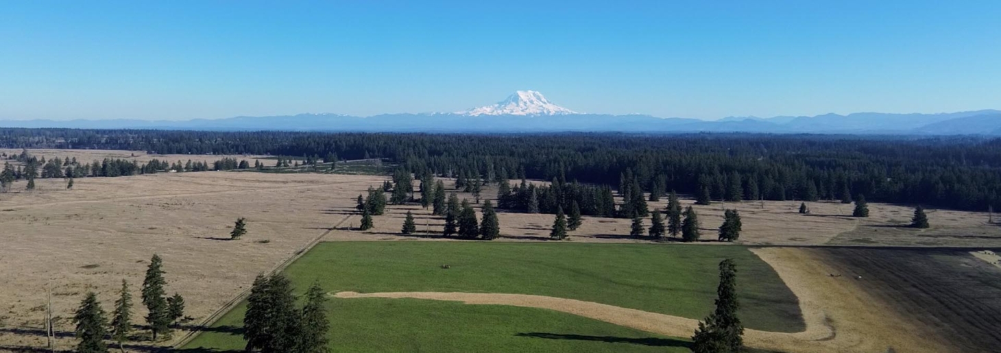
Running N Ranch is a rare, large-format North Texas ranch near Saint Jo, source-listed at 1,185.16 acres / 479.62 hectares with a mix of wooded ridges, grassland, water bodies, creek boundary, wells, and working-ranch improvements. For Resilience Atlas, the property stands out because it is not just acreage; it has a clear sense of place, meaningful water assets, strong visuals, and enough existing infrastructure to support staged use.
The most important resilience strengths are water diversity, scale, privacy, and practical infrastructure. The listing describes four ponds, a fifth pond under construction, Clear Creek along approximately 1.42 km / 0.88 miles (4,670 linear feet) of boundary, two wells, natural springs in valley bottoms, power lines, roads, fencing, cattle pens, and multiple buildings or amenity structures.
The concerns are equally material. No mineral rights convey, pipeline and easement issues are present, septic status is unknown, communications are not documented, floodplain/wetland status along Clear Creek has not been checked, and former gravel-mine areas require environmental and safety review. This is a strong candidate, but it is not a casual purchase.
Initial Verdict:
Strong Resilience Atlas candidate for a well-capitalized buyer seeking a legacy-scale ranch with water, privacy, and infrastructure — provided title, easements, water, septic, communications, floodplain, and environmental questions are resolved before purchase.
Key Strengths
- Exceptional scale: 1,185.16 acres / 479.62 hectares of contiguous ranch land.
- Major water story: ponds/lakes, Clear Creek boundary, two wells, and claimed springs.
- Strong working-ranch base with fencing, cattle pens, roads, workshop/storage, office/camphouse, gazebo, dock, and power-line presence.
- Mix of wooded acreage, grassland, bluffs, valleys, and open pasture gives both utility and visual quality.
- Close enough to Saint Jo for practical access while still offering meaningful privacy and separation.
Key Concerns
- No mineral rights convey; pipeline, mineral, access, and electric easements must be reviewed carefully.
- Septic status is unknown despite a restroom being mentioned in the office/camphouse.
- Communications, broadband, cellular coverage, and Starlink suitability are not documented in the listing.
- Floodplain, wetland, drainage, and erosion constraints along Clear Creek, ponds, and bottomland remain unverified.
- Former gravel-mine/reclaimed lake areas need environmental, geotechnical, safety, and liability due diligence.
Location Analysis
Regional Context
The ranch sits along FM 3206 near Saint Jo in Montague County, Texas. The listing places it 4.43 km / 2.75 miles southwest of the Saint Jo city limits; an independent OSM/OSRM road-route check from the listing coordinates puts Saint Jo town center at approximately 5.4 km / 3.4 miles by road, about 7 minutes.
This is a rural North Texas setting with small-town access, working-ranch context, and enough distance from larger cities to feel distinct. Gainesville is approximately 43.4 km / 27.0 miles by road, about 35 minutes, and Decatur is approximately 67.0 km / 41.6 miles by road, about 66 minutes.
Access and Roads
The listing claims approximately 1.83 km / 1.14 miles of frontage on FM 3206, two gated entrances, and additional deeded easements, including access from Hwy 59 and Quarry Road. Those are significant access advantages, but title work must confirm the exact legal access rights, maintenance duties, and whether all internal roads remain usable after wet weather.
Distance to Services
- Saint Jo: approximately 5.4 km / 3.4 miles by road; about 7 minutes.
- Saint Jo Fire Department: approximately 5.6 km / 3.5 miles by road; about 7 minutes.
- Nocona: approximately 27.7 km / 17.2 miles by road; about 23 minutes.
- Nocona General Hospital: approximately 28.9 km / 17.9 miles by road; about 26 minutes.
- Gainesville: approximately 43.4 km / 27.0 miles by road; about 35 minutes.
- North Texas Medical Center, Gainesville: approximately 40.5 km / 25.2 miles by road; about 34 minutes.
- Bowie, Montague County: approximately 42.2 km / 26.2 miles by road; about 41 minutes.
Land and Terrain
Acreage Usefulness
The source describes about 500+/- acres / 202.34 hectares of grass and 685+/- acres / 277.21 hectares of woods, with a 20-acre / 8.09-hectare improved bermudagrass bottom pasture. That mix supports cattle, wildlife, privacy, shade, firewood/timber potential, and selective food-production zones.
Soil and Growing Potential
The ranch has working cattle history and improved pasture, which is encouraging for practical land use. Soil productivity, garden suitability, orchard potential, erosion risk, and septic suitability still need soil-map review, field inspection, and local testing.
Water Features
Water is the property’s defining resilience feature. The listing describes four ponds, a fifth pond under construction, named lakes including Quarry Lake, Twin Oaks Lake, and Sparrow Hawk Lake, Clear Creek along the southwestern boundary, natural springs, and two wells. The practical question is not whether the listing has a water story; it is whether each water source is reliable, legally usable, safe, and resilient through drought.
Utilities and Infrastructure
Power
Pentex Energy power lines are source-listed on the property, and the listing says electrical service lines are established in several locations and can be extended to desired locations. Confirm meter status, line condition, service capacity, and extension costs before relying on this for build planning.
Water
Two wells are listed. One reportedly serves the office/workshop area and has a large-capacity storage tank; the second is farther south and currently used for livestock watering. Obtain well logs, pump tests, water-quality tests, equipment inspection, storage-tank details, and any use constraints.
Septic and Waste
Septic is unknown. The source mentions a restroom in the office/camphouse but does not identify a septic system, permit, condition, or legal status. This is a priority due-diligence item.
Internet and Communications
The listing does not document broadband, fiber, cable, cellular coverage, or Starlink conditions. Because reliable communications matter for emergency response, remote work, monitoring systems, and long-term livability, a buyer should test major carriers on site, check FCC/provider maps, evaluate Starlink obstruction, and consider GMRS/ham-radio conditions.
Off-Grid and Resilience Potential
Solar Suitability
No installed solar system is listed. However, the mix of open grassland, road access, utility corridors, and large acreage suggests strong physical potential for ground-mounted solar and battery backup if zoning, orientation, shading, and interconnection/off-grid rules allow it.
Heating and Cooling
North Texas heat, hail/wind exposure, and occasional cold events should shape any build plan. Wooded acreage may offer firewood potential, but wildfire risk, burn practices, insurance, and sustainable cutting should be verified. A resilient buildout would likely combine efficient heat pumps, propane backup, shade strategy, and generator/solar redundancy.
Food Production Potential
The ranch is already used for cattle grazing and recreation, and the grass/timber mix supports livestock, gardens, orchards, wildlife habitat, and managed pasture improvements. Water access and soil testing will determine how much of that potential is practical rather than theoretical.
Security and Privacy
Large acreage, gated entries, bluffs, wooded draws, and distance from town support privacy and site control. This should be framed as practical land stewardship and privacy, not as a defensive fantasy; emergency access, road conditions, and neighbor/easement rights remain important.
Legal, Zoning, and Buildability
Zoning
The listing claims no deed restrictions, but zoning and land-use rules were not verified in the evidence pack. Confirm county/jurisdiction rules for residences, cabins, RV stays, multiple dwellings, hunting/recreational use, commercial activity, subdivision, short-term rental, and off-grid systems.
Permits and Restrictions
Title review is critical. The listing states no mineral rights convey and identifies electric, pipeline, mineral, and access easements. A cattle grazing lease is listed as expiring May 31, 2026. Any purchase analysis should include recorded easements, mineral reservations, pipeline documents, grazing lease terms, survey, road maintenance obligations, and environmental liabilities tied to former gravel-mine use.
Risk Assessment
Environmental Risks
Clear Creek, ponds/lakes, bottomland, bluffs, reclaimed mining areas, and steep terrain all add value and risk. FEMA floodplain/wetlands, drainage, erosion, bank stability, pond/lake safety, wildfire exposure, drought resilience, and storm/hail insurance should be checked before serious commitment.
Financial / Practical Cost Risks
This is a $10,000,000 listing with large-acreage maintenance demands. Even with existing improvements, the buyer should expect significant inspection, legal, road, fencing, utility, insurance, water, septic, and land-management costs. The current ag exemption and 2024 taxes of $1,090 are useful listing claims, but continuation requirements after transfer must be confirmed.
Practical Risks
The main practical risks are not remoteness alone; they are complexity. Mineral non-conveyance, pipeline/easement constraints, uncertain septic, unknown communications, possible floodplain/wetlands, former gravel-mine areas, and cattle-lease timing all require disciplined due diligence.
Estimated Development Path
Phase 1: Due Diligence
Before purchase, confirm survey, title, legal access, easements, mineral reservations, pipeline documents, floodplain/wetlands, zoning/buildability, no-deed-restriction claims, lease terms, well performance, septic/permitting, environmental history, road condition, insurance, utilities, and communications.
Phase 2: Basic Use
Initial use could focus on confirming water systems, cleaning/assessing roads, testing communications, inspecting buildings and fences, clarifying cattle-lease transition, securing gates, verifying power, and establishing a safe temporary base around the existing office/workshop area if legally permitted.
Phase 3: Resilient Buildout
A long-term buildout could add a permitted home or retreat compound, solar plus battery backup, generator redundancy, water storage and filtration, garden/orchard zones, livestock systems, greenhouse, wildfire/erosion management, communications equipment, and a stewardship plan for ponds, creek corridors, grassland, and woods.
Property Scorecard
Four existing ponds, a fifth pond under construction, Clear Creek boundary, two wells, and claimed springs give this ranch unusually strong water potential; well yield, water quality, and floodplain constraints still need verification.
At roughly 1,185.16 acres / 479.62 hectares with wooded draws, bluffs, and only limited public-road frontage, the ranch offers high privacy while still remaining near Saint Jo.
The grass/timber mix, cattle history, 500+/- grass acres / about 202.34 hectares, and 20 acres / 8.09 hectares of improved bermudagrass support grazing and homestead-scale food systems if water and soils check out.
Existing power lines, wells, fencing, cattle pens, office/camphouse, workshop, storage, gazebo, and dock are meaningful starts, but septic, building status, and condition are not confirmed.
Large acreage, water diversity, timber, open solar-suitable pasture, and existing utility corridors create a strong off-grid/back-up-power platform, though no installed solar or independent systems are listed.
The source listing does not document broadband, fiber, cellular coverage, or Starlink conditions, so communications remain a major due-diligence item despite the property’s manageable distance to nearby towns.
Bluffs, elevation change, wooded draws, gated access points, and broad internal scale create useful privacy and site-control advantages without relying on exaggerated security claims.
North Texas ranch land can be productive and livable, but drought, heat, wildfire, hail/wind, drainage around creek bottoms, and water reliability require site-specific review.
Water, pasture, timber, wildlife habitat, existing ranch infrastructure, and enough scale for phased systems make this a strong self-reliance candidate if legal, utility, and environmental issues clear.
The listing has exceptional visual and narrative depth: legacy ranch scale, Clear Creek, lakes, bluffs, working-ranch history, Chisholm Trail context, and strong media support.
Big-sky pasture, lakes, bluffs, old-family ownership, cattle use, and a clear legacy-ranch identity make it a memorable Resilience Atlas feature property.
FM 3206 frontage, two gated entrances, and claimed deeded easements are positives, but title, easements, no-deed-restriction claims, zoning, septic, and pipeline/mineral constraints must be confirmed.
Overall score: 92/120 (77%). Running N Ranch is a high-quality flagship candidate because of its scale, water, terrain, ranch infrastructure, and media strength, with the main drag coming from communications, legal, septic, floodplain, mineral, and pipeline unknowns.
Final Recommendation
🟢 Strong Candidate — pursue deeper due diligence
Running N Ranch is one of the stronger Resilience Atlas-style properties because the fundamentals align: meaningful water assets, large scale, privacy, mixed terrain, existing ranch infrastructure, visual appeal, and a credible phased-use path. It has the substance to support a full property intelligence report and the visual/narrative depth to serve as a flagship public feature.
The recommendation is conditional in practice even though the candidate rating is strong. A buyer should not proceed without a careful title/easement review, mineral and pipeline analysis, floodplain/wetland checks, well and septic verification, environmental review of former gravel operations, communications testing, and a clear plan for maintaining a property of this size.
Rating context: Candidate levels reflect how well the property fits Resilience Atlas criteria after weighing infrastructure, water, access, buildability, communications, risk, and unresolved due diligence.
Questions to Ask Before Moving Forward
- Is the exact legal acreage and boundary survey current?
- What recorded easements affect access, utilities, minerals, pipeline rights, and road use?
- What does “no deed restrictions” mean after full title and covenant review?
- What county or jurisdiction rules apply to residences, cabins, RVs, multiple dwellings, short-term rental, hunting, and off-grid systems?
- What are the well depths, yields, pump condition, storage-tank condition, and water-quality results?
- Is there a permitted septic system serving the restroom, and can the property support future septic/perc needs?
- Are Clear Creek, ponds, lakes, bottomland, or reclaimed gravel-mine areas in floodplain, wetlands, or regulated drainage areas?
- What environmental or geotechnical liabilities may be associated with the former gravel mine and reclaimed lakes?
- What are the exact terms of the cattle grazing lease through May 31, 2026?
- What are the service details and extension costs for Pentex Energy power?
- Which cellular providers work on site, and is Starlink practical at intended build locations?
- Can the ag exemption continue after transfer, and what are the rollback-tax or use-change risks?
- What insurance is available for ranch liability, water features, wildfire, hail/wind, flood, vacant structures, and future improvements?